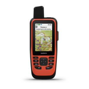
Garmin GPSMAP 66i including Topoactive Europe Maps
The GARMIN GPSMAP 66i is the perfect combination of navigation device and InReach satellite communication!
395,00€ (ex.vat) 489,80€ (incl.vat)
Available on backorder
- Worldwide two-way communication and 24/7 SOS emergency function via Iridium satellite system
- Live tracking independent of the cellular network
- GPS & GALILEO for position determination
- Lithium battery with a runtime of up to 200 hours (depending on the live tracking setting)
- Dimensions of 6.6 x 16.3 x 3.5 cm and a weight of 241 g
- 3-inch display with 240 x 400 pixel resolution
- Waterproof according to IPX7 and shock and temperature resistant according to MIL-STD-810G
- 16 GB internal memory, microSD card
- Barometric altimeter, 3-axis compass
- High-speed USB, Bluetooth LE
- Garmin Connect IQ compatible (apps, widgets, data fields)
- Connection to Garmin Explore
- The weather forecast has also been available via Iridium since October 31, 2019
- Pre-installed Garmin TopActive map of Europe, Birdseye satellite images included, additional countries / continents can be purchased
- Help in need. Always and everywhere. Connected at any time to the global GEOS search and rescue control center via direct communication and an emergency button; reachable worldwide. Even without a wireless network. Write and receive messages using InReach technology over the global Iridium satellite network. (Satellite subscription required)
- Navigating the terrain. More than precise. Thanks to the quad-helix antenna, support from GPS and GALILEO and self-calibrating ABC sensors. Pre-installed Garmin TopoActive Europe maps with BirdsEye satellite imagery downloads straight to the device (no annual subscription required);
- Cellular use for access to active weather forecasts and geocaching live
- Plan your tours with the Garmin Explore ™ website and app. Manage waypoints, routes, activities and collections, use tracks and view the data on your adventures.
- Up to one week of battery life (lithium battery): 200 hours in expedition mode with 30-minute tracking intervals, up to 35 hours of battery life with 10-minute tracking
- The corresponding tariffs can be booked at the same time!
- Can be extended to ProteGear SmartSafety , the safety system with automatic dead man’s switch
Note for current owners of InReach devices: Your InReach data tariff and account can easily be transferred to a GPSMAP66i, the old InReach is automatically logged off.
Other differences to InReach Explorer +:
- The OSM maps for the whole world are available free of charge on the Explorer +, at least the GARMIN maps (except for Europe) are chargeable on the GPSMAP66i. However, there are plenty of Garmin-compatible maps online that can also be loaded onto the 66i via “Garmin BaseCamp”.
Scope of delivery:
- GPSMAP66i + with wrist strap and carabiner
- including maps of Europe
- USB cable for charging and syncing
- Instructions in German
Special version with external Iridium antenna connection (Female-SMA) available.
Additional information
| Brand | Garmin |
|---|